|
|
SUBJECTS |
TITLES |
AUTHORS |
PUBLISHERS |
Exercise Books |
|
1 |
PURE MATHEMATICS |
Explaining Pure Mathematics for A/L |
ATANGA N. |
NAARAT |
300 register |
|
2 |
FURTHER MATHEMATICS |
An Intergrated Core Approach |
PLANKEH A. |
QUALITY PRINTERS |
300 register |
|
3 |
MECHANICS |
A/L Mechanics and Probability |
ATANGA N. |
NAARAT |
300 register |
|
4 |
FURTHER MECHANICS |
An Intergrated Core Approach |
PLANKEH A. |
QUALITY PRINTERS |
200 register |
|
5 |
PHYSICS |
New-Look Advanced Physics |
KIMAL Honour |
NMI |
500 ledger |
|
6 |
CHEMISTRY |
Advanced Chemistry |
Philip MATHEWS |
CAMBRIDGE |
500 ledger |
|
7 |
BIOLOGY |
Biology Science 1 and 2 |
D.J. TAYLOR |
CAMBRIDGE |
500 ledger |
|
8 |
STATISTICS |
Explaining A/Level Statistics |
ATANGA N. |
NAARAT |
200 ledger |
|
9 |
ICT |
Fundamentals of ICT |
NKAMENEI Denis |
QUQLITY PRINT |
200 ledger |
Name: Penn Emile Nkeng
Class: upper sixth scence GEOLOGY (23/04)
A hazard is an agent which has the potential to cause harm to a vulnerable target. Hazards can be both natural and human induced. A hazard is any agent that can cause harm or damage to humans, property, or the environment. Risk is defined as the probability that exposure to a hazard will lead to a negative consequence, or more simply, a hazard poses no risk if there is no exposure to that hazard. Natural hazards continue to pose a major threat to the entire world with prospects of even greater impacts to life and property in the future (Aini & Fakhrul-Razi 2010, Hayles 2010).
FLOODS
Flooding is as an overflowing by water of the normal confines of a stream or other body of water, or accumulation of water by drainage over areas that are not normally submerged. A flood occurs when water inundates land that's normally dry, which can happen in a multitude of ways.
Types and Causes of floods
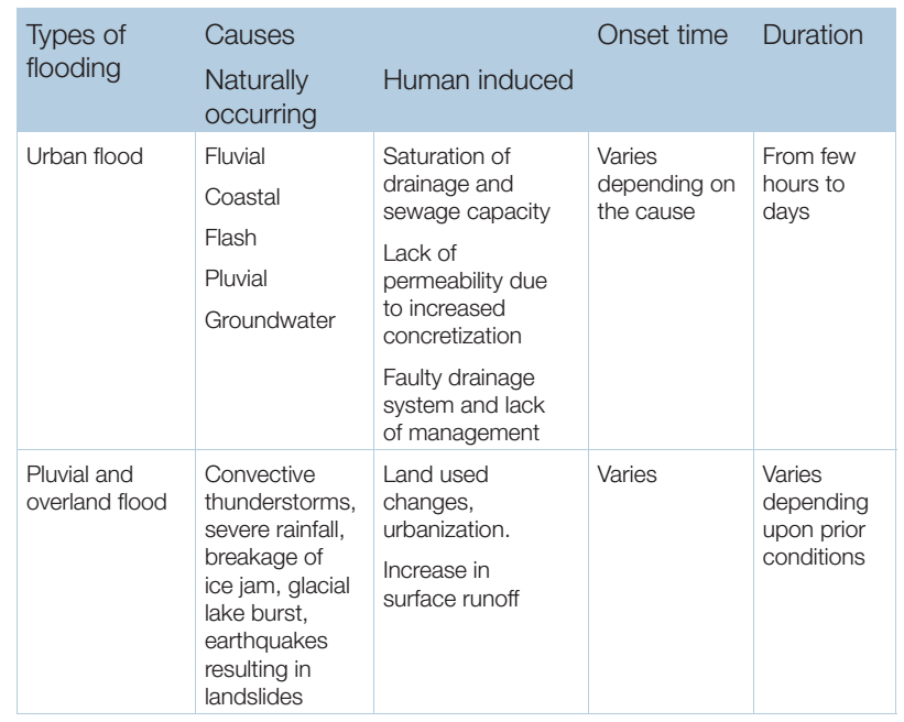
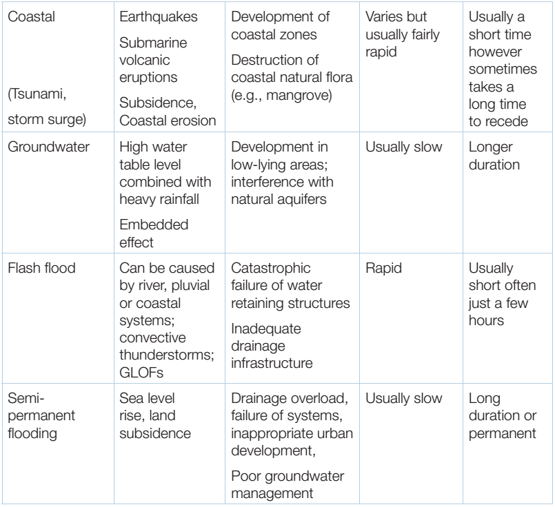
CAUSES OF FLOODING (Triggering Mechanisms of Floods)
These different types of flooding can be caused by the following factors;
EFFECTS OF FLOODING
FLOOD MONITORING
RADAR
Radar estimation of rainfall is widely used and is not strictly “emerging”. Radar provides
an aerial indication of rainfall, and so provides a better distributed measurement than from point
rain gauge measurements, with the output lending itself well to use in grid based models.
There are a number of limitations in measurement accuracy such as range, attenuation of
signal and calibration, but second-generation radar instruments, particularly Doppler radars,
have overcome some of the attenuation problems. Smaller radar instruments (C and X-band
radars), sometimes portable, are useful for local monitoring, especially in urban areas.
SATELLITE
Currently 28 space agencies along with 20 other national and international organizations participate in CEOS (Committee on Earth Observation Satellites) planning and activities. The NASA satellite monitoring Programme produces both real-time and research-merged 3-hour global precipitation products available on an ftp server for public access. However, this service requires considerable resources to support ground validation sites and research. Rainfall estimation from geostationary satellite platforms uses infra-red (IR) sensing based on the relationship between cloud-top growth and surface precipitation, and is best for convective rainfall.
PREVENTION AND MITIGATION OF FLOODING
Floods prevention and mitigation involves the management and control of flood water movement such; as reducing flood runoff through the use of flood walls and flood gates. It also involves the management of people through measures such as excavation and dry/wet proofing properties.
MITIGATION
It can be studied in three levels
METHODS OF FLOOD PREVENTION
Earthquakes
Earthquakes can be defined as sudden movement of the earth caused by the abrupt release of accumulated strain along a fault in the interior of the earth. The released energy passes through the earth as seismic waves (low frequency sound waves) which cause the shaking. Earth quakes are one of the most destructive natural hazards. Unlike volcanoes that occur only at certain plate margins, earth quakes occur in all plate margins. Similar to intraplate volcanism (hot spot), earth quakes also occur within plates as a result of reactivation of faults.
Spatial distribution of earth quakes in Cameroon
There are four main seismogenic zones in Cameroon (Noel et al., 2014). The first zone is found in the south west of Cameroon (Mount Cameroon). This zone is related to volcanism, 94% of seismic events in Cameroon occur in this region. The maximum event has a magnitude of 4.4 (Noel et al., 2014). The second seismic zone is located north of mount Cameroon volcano and it is associated with central Cameroon shear zone (CCSZ). It has weak to moderate earth seismicity. The maximum magnitude recorded in this zone is 5.1(Noel et al., 2014). The third seismic zone is associated with the Sanaga fault zone. The focal depth here is 33km and the maximum magnitude of earth quake is 5.8 (figure2)
The fourth seismic zone is located at the northern boundary of the Congo craton. Focal depth of 33km has been registered and a maximum magnitude of 6(Noel et al., 2014)
They are three major types of earth quake; tectonic earth quake, volcanic earth quake and human induced earth quake.
1) Tectonic earth quake
Tectonic earth quake is caused by deformation of rocks within the earth’s crust. Faulting is the main mechanism through which tectonic earthquakes occur. The movements of lithospheric plates past one another are slowed by friction along plate boundaries. In so doing, stress builds up and rocks are strained and deformed. As the stress exceeds the strength of the rocks, the rocks rupture and produce faults (release energy contained within) hence generating earth quake. The rupture produces earth quake waves or seismic waves (elastic strain energy that propagate through the earth). The seismic waves travel through the earth surface and cause destruction of buildings and property damage.
2) Volcanic earth quake
Volcanic explosions caused by the escape of gas release elastic waves. These waves travel through the surface causing earth quake. Ascend of magma from the earth surface to the shallow magma chamber equally cause stress on the rocks resulting to earth quake.
3) Human induced
There are human activities that can cause earth quake; loading the earth crust(building a dam and reservoir, waste disposal deep into the earth’s crust(disposal wells) underground nuclear explosions.
Disposal of liquid waste in deep wells result in faulting. For example in Denver Colorado an earth quake of magnitude 4.3 occurred as a result of disposal of liquid waste on tightly fractured metamorphic rocks. The liquid induced slippage along fractures causing earth quake.
LANDSLIDES
A landslide occurs when part of a natural slope is unable to support its own weight. For example, soil material on a slope with slippery surface underneath, can become heavy with rainwater and slide down due to its increased weight.
A landslide is a downward or outward movement of soil, rock or vegetation, under the influence of gravity. This movement can occur in many ways. It can be a fall, topple, slide, spread or flow. The speed of the movement may range from very slow to rapid. The mass of moving material can destroy property along its path of movement and cause death to people and livestock. Although landslides usually occur at steep slopes, they may also occur in areas with low relief or slope gradient. Determination of causative factors of landslide in any given area will also help in demarcating the landslide prone zones.
TYPES OF LANDSLIDES AND SLOPE FAILURES:
CAUSES OF LANDSLIDES
Many of the landslides are natural phenomenon that occurs independently of any human actions. There are also landslides that have been induced by the very actions taken to make land suitable for some human purposes. Landslides can be triggered due to external causes or internal causes.
External Causes
1. Undercutting of the foot of the hill slope due to river erosion, quarrying, excavation for canals and roads, etc.
2. External loads such as buildings, reservoirs, highway traffic, stockpiles of rocks, accumulation of alluvium on slopes, etc.
3. Increase in unit weight of slope material due to increased water content.
4. Vibrations due to earthquakes, blasting, traffic, etc., causing increase in shearing stresses.
5. Authropic changes caused by deforestation
6. Undermining caused by tunneling, collapse of underground caverns, seepage erosion, etc.
Internal Causes
1. Increase in pore water pressure.
2. Reduction in cohesive strength caused by progressive laterization.
3. Hair cracks due to alternate swelling and shrinkage from tension.
4. Presence of faults, joints, bedding planes, cleavage etc., and their orientation.
5. Freezing and thawing of rocks and soils.
6. Material properties such as compressive strength, shearing strength, etc., of earth
material.
TRIGGERING MECHANISM AND STRUCTURAL CONTROLE OF LANDSLIDE
Effect of Increase in Water Content
There is clear correlation between landslide activity and storms, as the saturation of earth material increases the pore water pressure. The addition of water to clay-bearing materials decrease cohesion and the angle of internal friction as well, leading to a decrease in shear strength (resisting force) and decrease in weight (driving force). Recurring landsides usually occurs in the years of high rainfall. Studies have shown that single short periods of heavy rainfall can trigger small landslides such as soil slips and debris flows, which affect only the near surface material. Deeper slides in unconsolidated materials will be triggered only by the cumulative effects of a series of storms. Bedrock slides appear to depend on the accumulation of precipitation over a long period of time during which precipitation consistently exceeds the average precipitation level for the region. A temporary rise in water pressure due to heavy rainfall in the material lying on the bedrock on a slope is sufficient to account for a decrease in strength, leading to debris slips and then debris flows.
Increase in Slope Gradient
Steeper the slope, greater is the chances of its failure. An increase in the steepness or gradient, of a slope leads to an increase in shear stress on the potential rupture plane and to a decrease in normal stress. Such increase in slope gradient may be due to undermining of the foot of the slope by stream erosion or by excavation. Exceptionally, the change of slope gradient may be produced by subsidence and upliftment of the earth’s surface.
Earthquake Vibrations
Vibration due to earthquakes not only triggers devastating landslides but also rock falls and the like. Earthquake shocks, particularly those of shorter duration, acceleration of ground motion, tilt of the slope, modifies the system of forces in a manner that driving forces get the upper hand. The vibrations generated by the vehicular traffic create oscillation of different frequency in rocks and they change the stress pattern, reducing shear strength and inducing mass movement.
Excess Load on the Slope
The addition of weight on the slopes like dumping of debris or wastes and the construction of dams, reservoirs, buildings, etc., increases the intensity of the driving force and reduces the slope stability.
Changes in Vegetation Cover
Vegetation helps in retaining the soil cover firmly. Trees with strong and long roots increase the cohesive strength and effectively hold the formations in to relatively weaker foundations increasing thereby the tensile and cohesive strength. However, surface growths of bushy plants promote greater seepage, which may lead to increasing pore pressure. In the absence of vegetal cover rainfall initiates, a set of process like rain slash erosion, sheet erosion and gully erosion, which ultimately results in to slope failure. The degree of effectiveness of the vegetation depends upon the condition of the soil, thickness of the overburden, slope, type of vegetation and climate.
▪ Clear the blocked drainage channels.
▪ Clear the debries, especially the huge rock boulders and tree trunks on the slopes.
▪ Stabilise the depositional area (characterized by loose soil, small rock boulders, etc.) by fast growing trees/plants.
Tsunamis
Tsunamis are secondary effect of earthquakes. Tsunamis are long wave length, small amplitude waves in the deep ocean called shallow water waves and when shaol in the continental shelf increase the wave height tremendously to inflict savage destruction by inundating the coastline.
Tsunamis are caused primarily by displacement of seabed from submarine or coastal earthquakes. Tsunamis are principally generated by undersea shallow earthquakes of magnitudes greater than magnitudes of 6.5 on the Richter scale (Crawford, US Army) especially at plate boundaries such as divergent plate boundaries.
There is no record of tsunami occurrence in Cameroon and as such case studies are from the coasts of the Indian Ocean and the Pacific Ocean.
From case studies, tsunamis have distinctive characteristics that make them different from one another. Some of these characteristics are discussed below;
Tsunami preparedness
Forest fires
A wildfire fire is an uncontrolled fire in an area of flammable vegetation that occurs in the countryside area. Reliant on the type of vegetation that is burned, a wildfire can also be classified as a brush fire, forest fire, desert fire, peat fire, grass fire, vegetation fire, or savannah fire.
Causes of wildfire ignitions are natural and anthropogenic; lightning, sparks from rock falls, volcanic eruption and spontaneous combustion. The thousands of coal seam fires that are burning around the world, such as those in Centralia, Burning Mountain, and several coal-sustained fires in China, can also sparkle up and ignite nearby flammable material. The most common human sources of wildfires are firebombing, discarded cigarettes, sparks from equipment, and power line. Ignition of wild land fires by contact with hot rifle bullet fragments is possible under the right conditions.
Wildfire impacts on people, property and natural resources
Volcanic hazards
The principal products of volcanic products may be grouped into several broad categories according to the type of material ejected and its mode of transport from the vents to its place of deposition: ash falls, pyroclastic flows, lava flows, and gas emissions.
Lava Flow
Lava flows are streams of molten rock that pour or ooze from an erupting vent. Lava is erupted during either non explosive activity or explosive lava fountains. Lava flows are one of the most familiar products of volcanic activity. They result when magma reaches the surface and overflows the crater or a volcanic vent along the flanks of the volcano The speed at which lava moves across the ground depends on several factors including;
(1) Type of lava erupted and its viscosity;
(2) Steepness of the ground over which it travels;
(3) Whether the lava flows as a broad sheet, through a confined channel, or down a lava tube; and
(4) Rate of lava production at the vent.
EFFECTS OF LAVA FLOW
Poisonous Gas Emissions
Volcanoes emit gases that are poisonous to living organisms. Among these gases are Hydrogen chloride, Hydrogen sulfide, Hydrogen fluoride and Carbon dioxide. These gases can be ejected during the eruption of a volcano or without a triggering eruption. They are transported away from vents as acid aerosols, as compounds absorbed by tephra and as microscopic salt particles.
Pyroclastic activity
This is one of the dangerous aspects of volcanism. Ash falls during volcanic eruption generally do not directly endanger life, although the collapse of roof and houses under the ash load are not common. Ash falls destroys vegetation, including crops and can kill livestock that eat the ash covered vegetation. It can cause loss of agricultural activity for years after an eruption.
Lahars (mudflows)
This is a mixture of water and sediments, they move rapidly down slope along streams valleys, although they may easily top banks and flood out into surrounding area. They have properties that vary between thick water and wet concrete, and can remove anything in their paths like bridges, highways and houses.
|
Hazards |
Destructions |
|
Landslides |
-Loss of life - Loss of property and assets - Loss of infrastructure and lifeline facilities - Loss of Resources
|
|
Floods |
-Floodwater can seriously disrupt public and personal transport by cutting off roads. - Floods disrupt normal drainage systems in cities, and sewage spills are common. - Floods can distribute large amounts of water and suspended sediment over vast areas, restocking valuable soil nutrients to agricultural lands. |
|
Forest fires |
Wildfires can cause wide damage, both to property and human life. |
|
Volcanic hazards |
-Loss of life and assets -Loss of vegetation
|
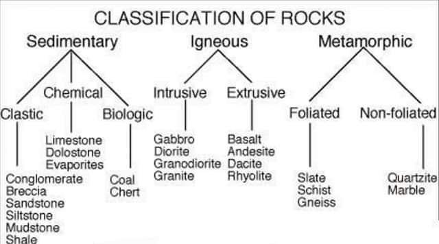
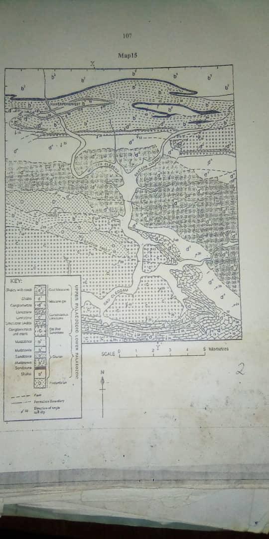

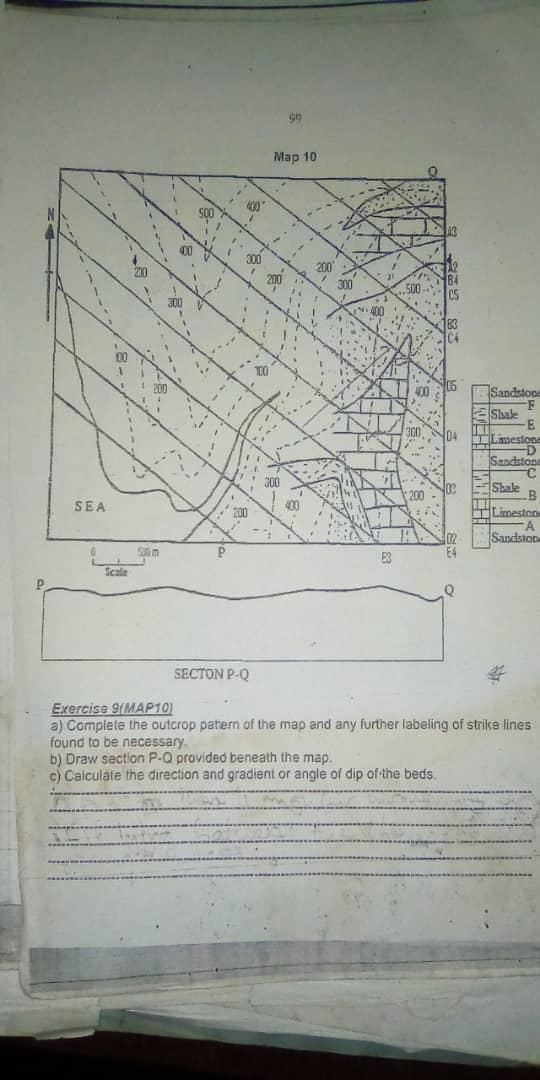
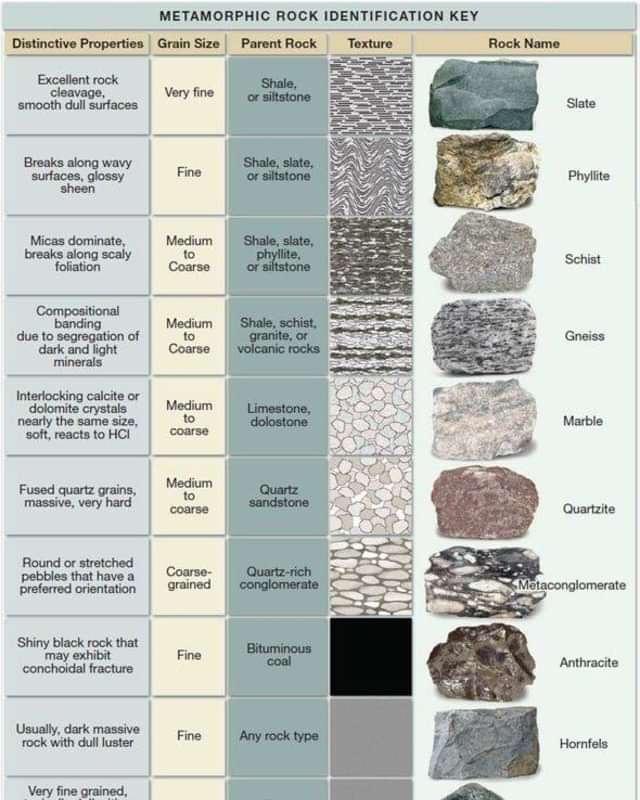
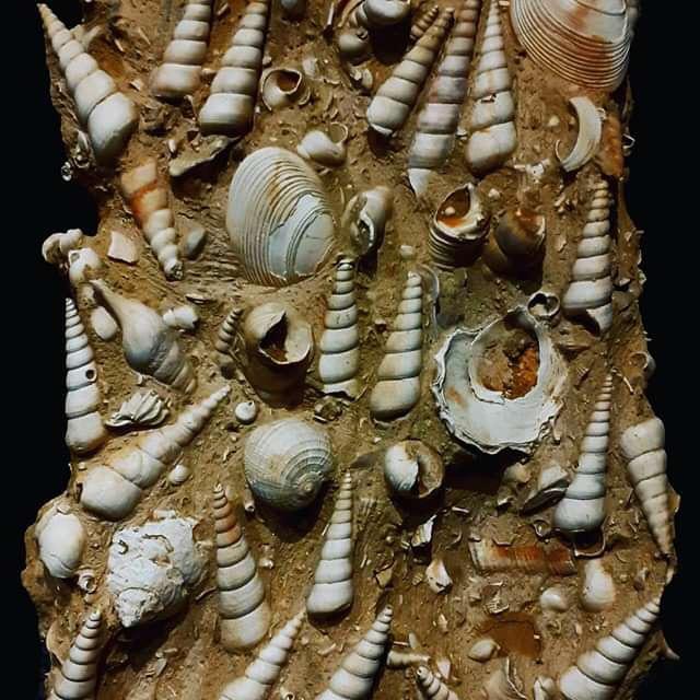
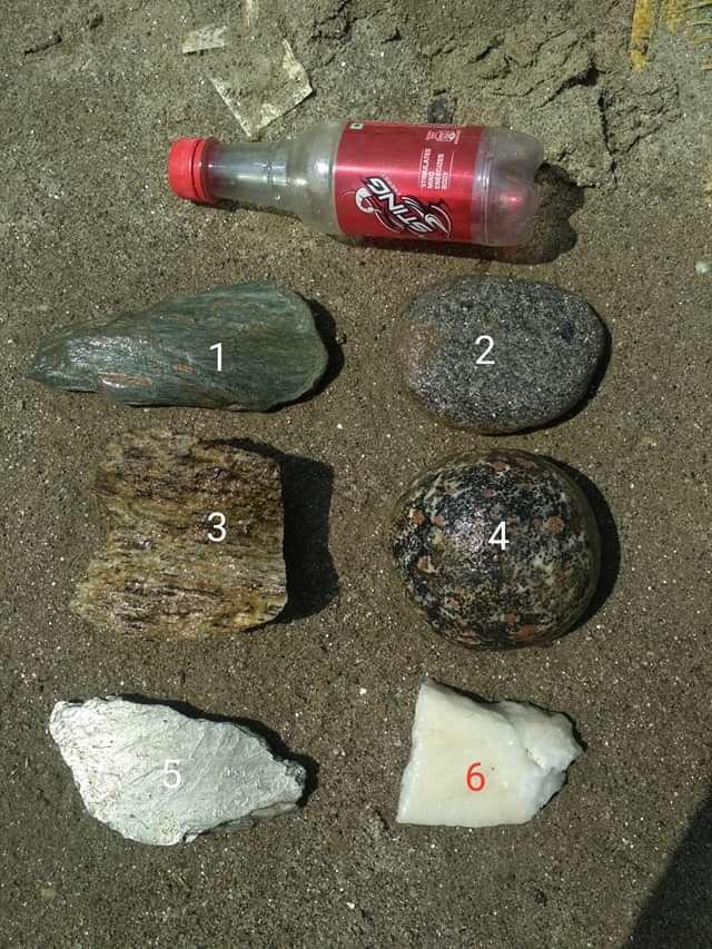
a) Identify the various types of fossils, b) Identify the above specimen
WEEK BEGINNING 23RD TO 27TH /03/2020
UPPER SIXTH. ORGANIC CHEMISTRY
7.LABORATORY PREPARATION OF ALDEHYDES AND KETONES
A.OXIDATION OF ALCOHOLS


B.FROM METHYLBENZENE
 C6H5CH3 SeO2/300°C C6H5CHO ( benzaldehydes)
II.CARTALYTIC OXIDATION
 2CH3CH2OH + O2 Agcat/500°C 2CH3CH2CH0 + 2H20
 2(CH3)2CH2OH + O2 Agcat/500°C 2CH3COCH3 (propanone)
C. BY DEHYDROGENATION OF ALCOHOL
 CH3CH2OH CU/300°C CH3CHO (ethanal) + H2
 (CH3)2CH2OH CU/350-380°C CH3COCH3 + H2
D.DECARBOXYLATION OF CALCIUM SALT OF CARBOXYLIC ACID
 (CH3COO)2Ca + (HCOO)2Ca dry distile/400°C 2CH3CHO + CaCO3 + 2CaCO3
 (C6H5COO)2Ca + (HCOO)2Ca dry distile/400°C 2C6H5CHO + 2CaCO3
  (CH3COO)2Ca + (CH3COO)2 distill 2CH3COCH3 + 2CaCO3
E.HYDROLYSIS OF A DIHALOGENO COMPOUNDS
 C6H5CHCL2 NaOH(aq)/REFLUX C6H5CHO
 CH3CHCL2 H2O/H+/REFLUX CH3CHO
  CH3CCL2CH3 H2O/H+/REFLUX CH3COCH3
F.FRIEDEL CRAFT ACYLATION
 C6H6 + (CH3CO)2O ALCL3/50°C REFLUX C6H5COCH3 + CH3COOH
 C6H6 + CH3COCL ALCL3/ REFLUX C6H5COCH3 + HCL
  CH3COCL + H2 POISON Pdcat/BaSO4 /HEAT CH3CHO (ITS IS USED FOR ALDEHYDES ONLY)
8.LABORATORY PREPARATION OF CARBOXYLIC ACID
A. OXIDATION OF 1° ALCOHOLS AND ALDEHYDES
 CH3CH2OH K2MnO4/H+/warm CH3COOH
 CH3CH2CHO K2MnO4/H+/warm CH3CH2COOH
SYNTHETIC ROUTE


B.FROM NITRILE (CN)
 CH3CH2CN concH2SO4/H2O CH3CH2CONH2 H2O/H+ CH3CH2COOH
C.HYDROLYISIS OF ESTERS

 CH3COOCH3 NaOH(aq)/ BOIL CH3COONa + CH3OH dilHCL CH3COOH
D. FROM GRIGNARD REAGENT

 CH3MgI + CO2 ether CH3COOMgI H2O/H+ REFLUX CH3COOH + Mg(OH)I
E. FROM OXIDATION OF METHYLBENZENE
 C6H5CH3 KMnO4/H+ /heat C6H5COOH
 II.FROM CANNIZZERO REACTION (aldehydes)

 2C6H5CHO concNaOH /40-60% at 25°C C6H5COONa +C6H5CH2OH HCL(aq) C6H5COOH + NaOH
III.HYDROLYSYS OF TETRA-CHLOROMETHYLBENZENE
 C6H5CCL4 dilHCL/BOIL C6H5COOH
9. LABORATORY PREPARATION OF ESTERS
A. FROM ESTERIFICATION REACTION
 CH3COOH + CH3CH2OH con H2SO4/HCL CH3COOCH2CH3 + H2O
B. FROM ACID ANHYDRIDES AND ALCOHOL
 (CH3CO)2O + CH3CH2OH REFLUX CH3COOCH2CH3 + CH3CH2OH
  CH3COOAg + CH3I CH3COOCH3 + AgI
II.FROM ACID CHLORIDES
 CH3CH2COCL + CH3CH2OH CH3COOCH2CH3 + HCL
10.LABAORATORY PREPARATION OF ACID CHLORIDES
 CH3CH2COOH + PCL5 CH3CH2COCL + POCL3 +HCL
 CH3COOH + SOCL2 CH3COCL + SO2 + HCL
  CH3COOH + 2PCL3 HEAT CH3COCL + P2O3 + 3HCL
11.LABORATORY PREPARATION OF ACID ANHYDRIEDS
A. FROM ACID CHLORIDES AND SALT OF CARBOXYLIC ACID
 CH3COCL + CH3COONa distill/reflux (CH3CO)2O + NaCL
12.LABORATORY PREPARATION OF AMINES (NH2)
A. FROM AMIDES (reduction of one carbon chain / Holfmandagradation reaction)
 CH3CONH2 + Br2/KOH/warm CH3NH2
B. REDUCTION OF NITRILES (CN)
 CH3CH2CN LiALH4/DRY ETHER CH3CH2CH2NH2
C.FROM HALOALKANES
 CH3CH2CH2Br + NH3 seal tube CH3CH2CH2NH2
D. FROM ALDEHYDES AND KETONES
 CH3CHO + NH3 H2/Nicat/high temp CH3CH2NH2
 CH3COCH3 +NH3 H2/Nicat/high temp CH3CH(NH2)CH3
 C6H5CHO + NH3 H2/Nicat/high temp C6H5NH2(phenylamine )
 E.REDUCTION OF NITRO GROUP ( NO2)

P.O.Box 1377 Douala
Douala, Cameroon
Mobile :
(237) 677 78 18 01 /677 33 71 36 / 694 50 55 41
U.K Number : 0442084276532 / 00447523738337
Phone : (237) 243 37 74 41
Email : info@newhopeandkingdavid.com